
Bhitarkanika National Park is a 145-square-kilometer (56-square-mile) national park in eastern India in Odisha’s northeast Kendrapara district. It was designated on September 16, 1998, and was designated as a Ramsar site on August 19, 2002.
After Chilika Lake, the area has been classified as the state’s second Ramsar site. Bhitarkanika Wildlife Sanctuary, which covers an area of 672 km2, surrounds it (259 sq mi). The Gahirmatha and sea sanctuaries are in the east, to separate mangroves from the swamp area and bay of Bengal. The rivers Brahmani, Baitarani, Dhamra, and Pathsala inundate the national park and wildlife sanctuary. It is India’s second-largest mangrove environment and home to a variety of mangrove species.
Saltwater crocodiles (Crocodylus porosus), Indian pythons, king cobras, black ibis, darters, and a variety of other flora and fauna can be found in the national park.
Fauna
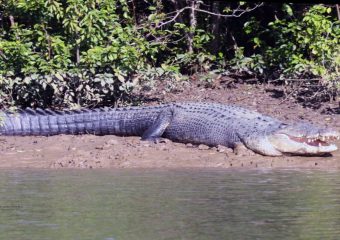
The saltwater crocodile, Indian python, black ibis, wild boar, rhesus monkey, chital, darter, cobra, and monitor lizard all live in the park. On Gahirmatha and other nearby beaches, olive ridley turtles lay their eggs. Bhitarkanika is home to one of India’s greatest populations of endangered saltwater crocodiles, with 10% of adults over 6 meters in length. The rivers and creeks are home to over 1671 saltwater crocodiles. During the yearly breeding and nesting season in 2014, approximately 3,000 saltwater crocodiles were born.
According to a 2014 mammalian survey, which was the first of its type in the park’s forest and wetland sections, 1,872 spotted deers and 1,213 wild boars have made the forest areas their home. According to the study data, monkeys account for 1,522, jackals for 305, common langur for 39, otter for 38, sambar deer for 17, jungle cat for 11, fox for 10, mongoose for 7, wolf for 7, and fishing cats for 12.
There are 320 species of birds in the avifauna, including eight kingfisher species. The park is home to a variety of birds, including Asian open bill, cormorants, darters, black ibis, and egrets. During the monsoon season, around 120,000 winter visitors from overseas and 80,000 resident birds from various areas of India arrive at the nest.
Flora
Mangroves are salt-tolerant, complex, and dynamic eco-systems that can be found in tropical and subtropical intertidal environments. In the estuarine region of Brahmani – Baitarani in the north-eastern portion of Odisha’s Kendrapara district, Bhitarkanika is one such site with a rich, lush green, dynamic ecosystem. A network of waterways runs across the area, with the Bay of Bengal to the east. The second-largest sustainable mangrove ecosystem in India is found in the alley between meandering streams and rivers. Its 672 square kilometers of mangrove forest and wetlands are home to over 215 species of birds, including winter migrants from Central Asia and Europe. This habitat, one of Asia’s most stunning wildlife sanctuaries, is home to giant saltwater crocodiles and a variety of other wildlife. The government of Odisha designated 145 km2 as Bhitarkanika National Park in September 1998, via Notification No.19686/F.Mangrove forests, rivers, creeks, estuaries, backwater, accreted land, and mudflats are all part of the ecological, geomorphological, and biological context. Bhitarkanika Sanctuary is centered around Bhitarkanika National Park.


Attraction
It’s a great place to see the massive Salt Water Crocodile, which can grow to be 23 feet long, as well as other reptiles like the Water Monitor Lizard and the King Cobra. The park is teeming with spotted deer and wild boars, which can be seen in all of the major areas. Eight different types of Kingfishers can be found here, and they can be seen along the park’s many creeks and rivers.
It is highly recommended to take the boat from Khola to Dangmal or vice versa. Khola is one of the park’s entrances. This is along an artificial creek that passes through the dense mangrove forest, giving visitors a glimpse of the estuarine ecosystem and its diverse fauna. Traveling through this creek is best done early in the morning or before sunset.
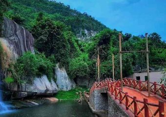
Bhitarkanika has a rich historical and cultural heritage. It was once the hunting grounds of Kanika’s former King. A variety of locales, including the Bhitarkanika path and Dangmal, include hunting towers and artificial drinking holes. It is also the location of medieval Hindu temples, which can be found throughout the sanctuary. However, the main draw continues to be the abundance of wildlife.