Barehipani Waterfall

Barehipani waterfall is one of the tallest waterfalls in India, which is situated inside the famous Similipal national park in the district of Mayurbhanj, Odisha. The total height of two-tier falls is 217m and is the second-highest waterfall in Odisha. The total height of Barehipani falls is 399 meters (1,309 feet). The highest single drop is 259 meters (850 feet).

Waterfalls are located on the Budhabalanga river flowing over Meghasuni mountain in east ghats on 21.932759n 86.380145e. The nearest railway station is in Baripada. Joranda waterfall is situated nearby. It is 120 km away from the city of jashipur.

The total height of Barehipani falls is 399 meters (1,309 feet). The highest single drop is 259 meters (850 feet).

Khandadhar Falls

Khandadhar falls is situated in Nandapani of Bonaigarh in Sundargarh district, the state of the Indian state of Odisha. It is India’s 12th highest waterfalls and the second highest in Odisha. It resembles a sword hence the name Khanda (Sword) Dhara Falls. A small stream (which is korapani Nala) plunges below the height of 244 meters (801 feet) in a single drop.

LOCATION:

The Khandadhar waterfall far from Rourkela via Bonaigarh is 104 km(65mi), and from Keunjhar is 132 km(82mi).

HISTORY:
There is an interesting legend among the Pauri Bhuiya tribal living in the vicinity of Khandahar. Legend has been reproduced from outlook (magazine). A Pauri Bhuiya legend explains how his mountain became so munificent. At one time in the Sundergarh branch of the community, there was the greedy goddess who used to eat trees, soil, and all other things. In despair, Pauri Bhuiya placed him on a rock which he ate – made a deep hole through which the Khandahar (dividing rock spring) turned out. So they had water. Then a pair of the community went to the eastern end of the Khandahar mountain range or to meet one of their relatives in Keonjhar. Their potential hosts were far away but a heap of grains was left out and surprisingly, birds were not even eating it. Inside the heap, the couple searched for a little goddess, Kanta Kumari, who was the savior of the prosperity of the region. They stole him and brought him back to Sundargarh, and so her reward became theirs.

EFFECT OF MINING:

The Kalinga commercial corporation limited operates the kurmitar mines located in the Khandahar hill range in 133 hectares. It exports manganese ore to China to iron ore and Korea. At the turn of the mountain top current, Khandadhara falls are partially dry. There are mines in the area spread 1,212 hectares has state-owned Odisha mineral corporation It has signed agreements with Adhunic Metaliks and Rexon Strips for the supply of iron ore. The government of Odisha intends to give 2,500 hectares of the lease to POSCO India. There has been local opposition and the matter has reached the courts. The court verdict is awaited till 2012.

Gandahati Waterfall

Gandahati waterfall is situated on the River Mahendratanaya in the Gajapati district, in the southern part of Odisha, India. From Parlakhemundi, the Gandahati waterfall is situated at a 30km distance. Its nearest railway station is Paralakhemundi and Palsa, which are 44 km far from Paralakhemundi. It is far away. The best an ideal opportunity to visit this spot is during the stormy season.

 A Gandahati waterfall is a tourist destination in the Gajapati district of Odisha, which is visited by many people during winters. This waterfall is 153 km away from Berhampur and 30 km from Parlakhemundi. its place can be accessed by bus or by any vehicle through road but by train, anyone can reach the 

waterfalls from either Palasa or Paralakhemundi

As soon as we go to the waterfall, we find it covered with dense forest all around. We must cross small villages along the path of waterfalls. After going 7 km from Parlakhemundi, we get a sprawling university campus which is called Centurion University. Those who come to this area, are also taking a look at this campus.

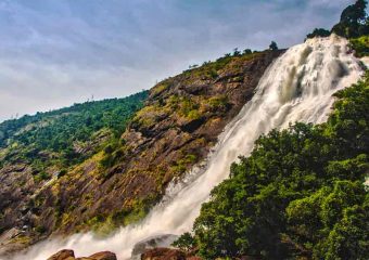
 The waterfalls are well known for shining waterfalls, in which water flows continuously throughout the year. Its natural beauty amidst the forests attracts tourists from all surrounding areas. A Hindu goddess Santoshi Maa temple is situated on the left side of the waterfall.

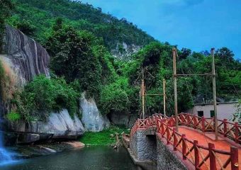
A bridge is over the stream to cross the path, which is made of wooden. The turning point is also a wooden fence from which we enter the falls area and take stairs near the waterfall. For children to play, a piece of the garden is maintained to entertain the visitors with tiny benches and other swings and all sorts of things.

The stream is not so deep that despite age everyone can easily get into the water and play there. Huge rocks at this place there is another viewpoint where people can sit and enjoy falling and take photos.

Duduma Waterfall

The Duduma waterfall are arranged in the limit of the Koraput (Odisha) and Visakhapatnam (Andhrapradesh) locale of India.

 The horsetail type of waterfall is of a height of 175 meters (574 feet) and formed by the river Machhkund. It has two subs – streams, one towards Odisha and the other towards Andhra Pradesh. The Duduma is around 92 km from Koraput and around 177 km from Visakhapatnam is far away.

This machhakunda is a pilgrimage. Near this waterfall are the aboriginal tribe of bonda, gadabas and parja are lived.

Machhakunda hydroelectric project is situated near Duduma waterfall. This is a collaborative project between government of Odisha and the government of Andhra Pradesh. The installed capacity of the project with six units is 120 MW.