Khandadhar Falls

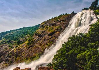
Khandadhar falls is situated in Nandapani of Bonaigarh in Sundargarh district, the state of the Indian state of Odisha. It is India’s 12th highest waterfalls and the second highest in Odisha. It resembles a sword hence the name Khanda (Sword) Dhara Falls. A small stream (which is korapani Nala) plunges below the height of 244 meters (801 feet) in a single drop.

LOCATION:

The Khandadhar waterfall far from Rourkela via Bonaigarh is 104 km(65mi), and from Keunjhar is 132 km(82mi).

HISTORY:
There is an interesting legend among the Pauri Bhuiya tribal living in the vicinity of Khandahar. Legend has been reproduced from outlook (magazine). A Pauri Bhuiya legend explains how his mountain became so munificent. At one time in the Sundergarh branch of the community, there was the greedy goddess who used to eat trees, soil, and all other things. In despair, Pauri Bhuiya placed him on a rock which he ate – made a deep hole through which the Khandahar (dividing rock spring) turned out. So they had water. Then a pair of the community went to the eastern end of the Khandahar mountain range or to meet one of their relatives in Keonjhar. Their potential hosts were far away but a heap of grains was left out and surprisingly, birds were not even eating it. Inside the heap, the couple searched for a little goddess, Kanta Kumari, who was the savior of the prosperity of the region. They stole him and brought him back to Sundargarh, and so her reward became theirs.

EFFECT OF MINING:

The Kalinga commercial corporation limited operates the kurmitar mines located in the Khandahar hill range in 133 hectares. It exports manganese ore to China to iron ore and Korea. At the turn of the mountain top current, Khandadhara falls are partially dry. There are mines in the area spread 1,212 hectares has state-owned Odisha mineral corporation It has signed agreements with Adhunic Metaliks and Rexon Strips for the supply of iron ore. The government of Odisha intends to give 2,500 hectares of the lease to POSCO India. There has been local opposition and the matter has reached the courts. The court verdict is awaited till 2012.

Duduma Waterfall

The Duduma waterfall are arranged in the limit of the Koraput (Odisha) and Visakhapatnam (Andhrapradesh) locale of India.

 The horsetail type of waterfall is of a height of 175 meters (574 feet) and formed by the river Machhkund. It has two subs – streams, one towards Odisha and the other towards Andhra Pradesh. The Duduma is around 92 km from Koraput and around 177 km from Visakhapatnam is far away.

This machhakunda is a pilgrimage. Near this waterfall are the aboriginal tribe of bonda, gadabas and parja are lived.

Machhakunda hydroelectric project is situated near Duduma waterfall. This is a collaborative project between government of Odisha and the government of Andhra Pradesh. The installed capacity of the project with six units is 120 MW.

Daringbadi

Daringbadi is a famous and spectacular hill station. which is situated in the Kandhamala district of the state of odisha in estearn india. Widely known as “odisha’s Kashmir”, it is located at an altitude of 915 m and is a popular tourist destination.

 In the days of British rule, there was a British officer named drawing sahib who was in charge of this place. Over the years, the place was named after him who spelt the meaning of the village along with the Daringbadi. More than 50% of the population here constitutes set community of aboriginal tribes.

 The temperature level of the Daringbadi is often recorded below 0 ° c. It is also well known for the production of improved quality of organic turmeric which is already G.I. tag. It is also famous for harvesting ginger.

To Travel:

 Regular bus services can reach Daringbadi (246 km) from the Bhubaneswar state Capital. The nearest railway station is in Brahampur (119 km).

 From Daringbari Berhampur it can be reached through sorda (nh-59) which is near about 120 km (75 miles), or Bhanjanagar – G.Udayagiri (nh-117) which is through the medium of approximately 180 km (110 miles) – the route of Bramhanigan which is about 145 km (90 miles)

It is about 49 kilometres (30 miles) from Baliguda, 30.5 kilometres (19.0 miles) from Raikia and 105 (65miles) kilometres from Phulbani.

Hirakud Dam

Hirakud dam is built in India about 15 kilometres (9 miles) from Sambalpur in the state of Odisha on the Mahanadi .There is a lake which is 55 km (34 miles) long behind the dam, Hirakud reservoir. It is one of the first major multipurpose river valley projects launched after independence of India.

 In June 1947, Hirakud dam project report was submitted to the government. Jawaharlal Nehru had placed the first batch of concrete on 12 April 1948.

 In the Mahanadi River upper drainage basin concentrated on the Chhattisgarh plain, the periodic drought is in contrast to the situation in the lower delta region where flood can damage crops. DAMS were constructed to help reduce these problems by creating a reservoir and controlling the flow of river through drainage system. The dam controls the flow of Mahanadi and produces hydroelectric power through many hydro – electric plants.

The dam helps in controlling the floods in the Mahanadi delta and irrigates the land of 75,000 km 2 (19×106 acres). Hydro electricity is also generated. The Hirakud dam controls 83,400 km 2 (20.6 × 10⁶ acres) of the Mahanadi drainage by controlling the reservoir has a storage capacity of 8.136 km3 (1.952 cubic miles) of 5.818 km3 (1.396 cubic miles) with a gross of 8.136 km3

It flows into an area of 133,090 km 2 (32.89 × 10⁶ acres), which is more than twice the area of Sri –Lanka.

 This project provides irrigation to 1,556 km 2 (384,000 acres) of kharif and 148,000 acres of rabi in sambalpur, bargarh, bolangir and subarnpur districts. The water left by the power plant is irrigated the CCA of 4,360 km 2 (1.08×10⁶ acre) in the mega river delta. On the right side of the dam, in burla, two power plants and 22 km (14 miles) from the dam to the bottom of the dam can generate electricity in 307.5 mw. Besides, the project provides flood protection in the 9,500 km 2 (2.3×10⁶ acre) delta areas in Cuttack and Puri district.

 Chiplima gained prominence as the second hydroelectric project in the Hirakud dam. The natural decline of Mahanadi River from 80 to 120 feet (24 to 37 m) is used for generating electricity. This place is inhabited by a large number of fishermen whose goddess Ghantashwari is worshipped in the neighbouring area. The state livestock breeding farms and agricultural farms are located here.

 Hirakud dam has three canals, namely the bargarh main canal, the sason canal and sambalpur canal. The bargarh main canal has a discharge rate of 4,000 cubic feet per second (110 m3 / s).

Later, water from the Hirakud dam was allotted to various industries, mainly for mineral processing and coal – based thermal power plants in the districts of Jharsuguda and Sambalpur.

 The main purpose of the hirakud dam was to stop the heavy flood which was affecting a large part of coastal Odisha. But, the construction of the dam deeply affected the original inhabitants of the western part of Odisha. The Hirakud project affected about 150,000 people and about 22,000 families migrated.

Now that place is a tourist place of Odisha