Mahendragiri

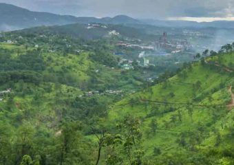
Mahendragiri is a mountain in the Rayagada sub – section of the Gajapati district of state Odisha in India. It is located at a height of 1,501 m (4,925 feet) between the Eastern Ghats. After Deomali, it is the second highest peak.

HISTORY:

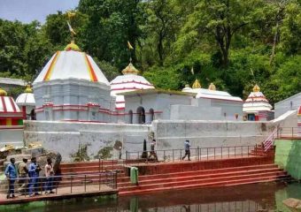
 Mahendragiri is associated with the Ramayana as the mountain of Mahendra pravata. Mahendra Giri is related to the name of Mahendra Parvati from Ramayana. Along with Malay, Sahyadri, Parijatra, Shuktiman, Vindhya and Malavayan, it is a Kul-pravat. The Puranas describe that when Lord Rama broke the sacred bow of Shiva, Parasurama was mediating on Mahendragiri. Mahendragiri is situated in the district of Gajapati of Odisha. The legend says that this is the place where Lord Parshurama, an eternal life, lives for all time and meditates. Parasurama is the sixth incarnation of Vishnu in the Hindu religion and he is one of the chiranjeevis, who will appear at the end of the Kaliyuga as the guru of Kalki, the tenth and last incarnation of Vishnu. He had many characteristics, including aggressiveness, war and heroism; Also, peace, sanity and patience. According to chapter 2.3.47 of Bhagavata Purana, he retired on the Mahendra Mountain. Only Vishnu avatar, who never dies never returns to abstract Vishnu and lives in meditation. Apart from this, he is the only Vishnu incarnation that exists in some of the versions of the Ramayana and the Mahabharata in conjunction with Rama and Krishna. The temples, which are said to have been built by the Pandavas. The primary celebration commended here is Shivratri.

REASION OF BIODIVERSITY HOT SPOT:

Mahendragiri Hill and its encompassing regions are perceived as biodiversity problem areas because of numerous restorative plants and different species found here. A heaven for therapeutic plants, Mahendragiri slopes, which is essential for the Eastern Ghats, is home to more than 600 blooming plants. The biodiversity of this region is very large and is known especially to be a herpetofaunal hotspot.

The ministry of environment and forests, government of India, in 1986, had proposed the state government of Odisha as Mahendragiri hill as biodiversity hotspot area. An expert committee of forest and environment department has also recommended that biodiversity hotspot Mahendragiri hills should be declared as a biosphere reserve in 2014.

The Mahendragiri biosphere save advisory group, which was set up in November 2011, held its last gathering in December, after which it presented its last report suggesting setting up a biosphere reserve at Mahendragiri hill complex.

 According to the survey conducted by the Odisha space application centre, core area 42.54 k. m Extends to 2 while the area of the buffer zone is 1577.02. m Transitional zone is estimated to be 3095.76 km 2. The entire biosphere reserve, 4715.32 km is proposed in the area.

Daringbadi

Daringbadi is a famous and spectacular hill station. which is situated in the Kandhamala district of the state of odisha in estearn india. Widely known as “odisha’s Kashmir”, it is located at an altitude of 915 m and is a popular tourist destination.

 In the days of British rule, there was a British officer named drawing sahib who was in charge of this place. Over the years, the place was named after him who spelt the meaning of the village along with the Daringbadi. More than 50% of the population here constitutes set community of aboriginal tribes.

 The temperature level of the Daringbadi is often recorded below 0 ° c. It is also well known for the production of improved quality of organic turmeric which is already G.I. tag. It is also famous for harvesting ginger.

To Travel:

 Regular bus services can reach Daringbadi (246 km) from the Bhubaneswar state Capital. The nearest railway station is in Brahampur (119 km).

 From Daringbari Berhampur it can be reached through sorda (nh-59) which is near about 120 km (75 miles), or Bhanjanagar – G.Udayagiri (nh-117) which is through the medium of approximately 180 km (110 miles) – the route of Bramhanigan which is about 145 km (90 miles)

It is about 49 kilometres (30 miles) from Baliguda, 30.5 kilometres (19.0 miles) from Raikia and 105 (65miles) kilometres from Phulbani.

Harisankar Temple

Harisankar temple situated in the slopes of the gandhamardhan hillsin the district of Balangir in Odisha in Ondia.

It is popular for its natural scenery and for its association with two Hindu gods, Vishnu and Siva. It’s such a beautiful tourist place. Every day there are lots of people coming here to visit. Here is waterfall also, that water fall attracts more people.

As a holy place, with a stream passing through the granite bed, it has given some visitors a feeling of peace. In front of the hills of Gandhamardana there is a temple of Narasimhanath. The plateau between the two temples has found ancient Buddhist ruins, considered to be the ruins of the ancient Perimalgiri University.

HISTORY:

 The god of harishankar was discovered in the 14th century by a Chauhan dynasty king of Patna state of Odisha. The goddess has been worshipped ever since. A dancing Ganesh statue has been found, which can be traced back to the beginning of the 12th century. The temple was built by the order of queen durlabha devi, then queen of king Vaijjal dev Chauhan.

LOCATION:

 It is situated in the district of Balangir of Odisha. The nearest railway station is on Harishankar road, which is only 32 km from the temple. Regular taxis are available for temple from this railway station.

FESTIVAL:

 Here all Ekadashi, Eankranti, Makar Sankranti, Shiva ratri, Megha mela festivals are celebrated.

Hirakud Dam

Hirakud dam is built in India about 15 kilometres (9 miles) from Sambalpur in the state of Odisha on the Mahanadi .There is a lake which is 55 km (34 miles) long behind the dam, Hirakud reservoir. It is one of the first major multipurpose river valley projects launched after independence of India.

 In June 1947, Hirakud dam project report was submitted to the government. Jawaharlal Nehru had placed the first batch of concrete on 12 April 1948.

 In the Mahanadi River upper drainage basin concentrated on the Chhattisgarh plain, the periodic drought is in contrast to the situation in the lower delta region where flood can damage crops. DAMS were constructed to help reduce these problems by creating a reservoir and controlling the flow of river through drainage system. The dam controls the flow of Mahanadi and produces hydroelectric power through many hydro – electric plants.

The dam helps in controlling the floods in the Mahanadi delta and irrigates the land of 75,000 km 2 (19×106 acres). Hydro electricity is also generated. The Hirakud dam controls 83,400 km 2 (20.6 × 10⁶ acres) of the Mahanadi drainage by controlling the reservoir has a storage capacity of 8.136 km3 (1.952 cubic miles) of 5.818 km3 (1.396 cubic miles) with a gross of 8.136 km3

It flows into an area of 133,090 km 2 (32.89 × 10⁶ acres), which is more than twice the area of Sri –Lanka.

 This project provides irrigation to 1,556 km 2 (384,000 acres) of kharif and 148,000 acres of rabi in sambalpur, bargarh, bolangir and subarnpur districts. The water left by the power plant is irrigated the CCA of 4,360 km 2 (1.08×10⁶ acre) in the mega river delta. On the right side of the dam, in burla, two power plants and 22 km (14 miles) from the dam to the bottom of the dam can generate electricity in 307.5 mw. Besides, the project provides flood protection in the 9,500 km 2 (2.3×10⁶ acre) delta areas in Cuttack and Puri district.

 Chiplima gained prominence as the second hydroelectric project in the Hirakud dam. The natural decline of Mahanadi River from 80 to 120 feet (24 to 37 m) is used for generating electricity. This place is inhabited by a large number of fishermen whose goddess Ghantashwari is worshipped in the neighbouring area. The state livestock breeding farms and agricultural farms are located here.

 Hirakud dam has three canals, namely the bargarh main canal, the sason canal and sambalpur canal. The bargarh main canal has a discharge rate of 4,000 cubic feet per second (110 m3 / s).

Later, water from the Hirakud dam was allotted to various industries, mainly for mineral processing and coal – based thermal power plants in the districts of Jharsuguda and Sambalpur.

 The main purpose of the hirakud dam was to stop the heavy flood which was affecting a large part of coastal Odisha. But, the construction of the dam deeply affected the original inhabitants of the western part of Odisha. The Hirakud project affected about 150,000 people and about 22,000 families migrated.

Now that place is a tourist place of Odisha